
Information about the route of Tectonic Ridge – Reselets Village eco-path
 From
Obrashtaloto parking lot, immediately before the watermill and
the fulling-mill, the eco path starts along an asphalt road
running parallel to Rachene Riverbed. The river spring is located
at the foothills of a large water catchment dry massif, and
due to the limited water flow rate, there is a rich biodiversity
eco-system near the riverbed.
From
Obrashtaloto parking lot, immediately before the watermill and
the fulling-mill, the eco path starts along an asphalt road
running parallel to Rachene Riverbed. The river spring is located
at the foothills of a large water catchment dry massif, and
due to the limited water flow rate, there is a rich biodiversity
eco-system near the riverbed.
To the left of the road, tourists can see and visit the active
watermill and fulling-mill and watch flour grinding by means
of stones driven by Rachene River, washing at the fulling-mill,
taste honey produced from the nearby beehives of the water-mill
owner or buy Reselets water onions.
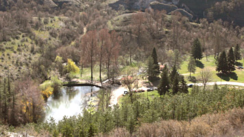
The route continues along the asphalt road to the wooden bridge
over Rachene River. On the other river bank, there is a recreational
zone with barbeque, and stone steps lead to Momina Salza Hut.
Here, there is a trifurcation of the path:
 A
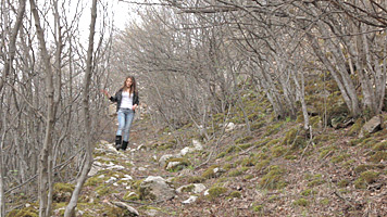
sign at the first fork directs along a narrow
forest path which, after 15 min walk, reaches Kaleto hill. On
the walk, tourists can see remnants of the ancient castle wall,
holly trees, lovely forest flowers, herbs, and mushrooms.
A
sign at the first fork directs along a narrow
forest path which, after 15 min walk, reaches Kaleto hill. On
the walk, tourists can see remnants of the ancient castle wall,
holly trees, lovely forest flowers, herbs, and mushrooms.
On the hill clearing, there is a viewing platform with alcove
and information sign. The platform provides panoramic view of
the surrounding rock heights and caves, Gadulkata rock formation
and part of the canyon.
On the Tectonic Ridge, a large number of protected rare birds
are nesting, and Karst formations are inhabited by bat colonies.
The mountain slopes are interspersed with over 200 kinds of
rare and beautiful plants.
 Along
the second fork, to the left of Momina Salza
Hut, along a narrow forest path running parallel to Rachene
River, tourist will enter a canyon, part of an old Roman road
which used to connect Ulpia Escus and Serdika. The path passes
through a pine forest where, nearing the ridge, in addition
to the amazing flora, one can see remains of Roman houses and
of the castle wall.
Along
the second fork, to the left of Momina Salza
Hut, along a narrow forest path running parallel to Rachene
River, tourist will enter a canyon, part of an old Roman road
which used to connect Ulpia Escus and Serdika. The path passes
through a pine forest where, nearing the ridge, in addition
to the amazing flora, one can see remains of Roman houses and
of the castle wall.
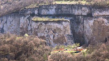
Kaleto Tectonic Ridge covers an area of 57.4
ha and is declared a protected territory by virtue of Order
№708/04.04.1961 of the Forest Authority.
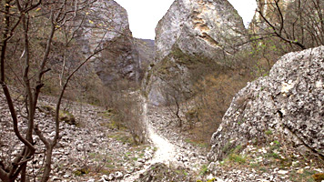
The unique natural phenomenon represents a region approximately
750 meters long, 30-40 m wide, with some 60 m flop. It is surrounded
on all sides by vertical rocks and can be accessed via a romantic
path running between them. The amazing diversity of geometric
rock formations is in complete contrast to the surrounding area.
The main cause for these formation is physical weathering, vertical
breaking of the 70-100 m thick Matricht limestone layers and
their horizontal displacement at a distance of 80-100 m. This
is one of the very few places in Bulgaria inhabited by scorpions.
The rocky walking terrain is interesting also for its fields
of wild cabbage, forest flowers, many endemites, and ivy trees
cutting into the rocks as if herbarized, and the birds circling
over add additional colorfulness to the view. The path runs
by the Split Rock – a large, slightly inclined
monolith block the size of a ten-storey building. The local
legend has that a girl who did not want to convert to Islam,
threw herself from the top. In anguish, the rock split.
 Several
interesting rock figures can be seen along the canyon, including
Gadulkata. One characteristic form of limestone terrains – caves,
here are not formed by ground waters and therefore lack stalactites
and stalagmites. The most remarkable cave of this route is the
Dark Hole. It lies between three limestone blocks which touch
one another at the top. The cave has the form of a three-wall
pyramid approximately 70 m high. One edge provides a narrow
entrance to the cave which, because of the draught, remains
cold and dark even in summer.
Several
interesting rock figures can be seen along the canyon, including
Gadulkata. One characteristic form of limestone terrains – caves,
here are not formed by ground waters and therefore lack stalactites
and stalagmites. The most remarkable cave of this route is the
Dark Hole. It lies between three limestone blocks which touch
one another at the top. The cave has the form of a three-wall
pyramid approximately 70 m high. One edge provides a narrow
entrance to the cave which, because of the draught, remains
cold and dark even in summer.
The floor is uneven, triangular, covered with weathered material
and moss mixed with the manure of thousands of bats inhabiting
the cave.
The Hearth is another naturally
formed spot in the rocks where fires smoke finds its way like
a chimney between rocks. This spot can be accessed through the
huge stone blocks called by the local denizens the Stone River.
Further, the path runs by the cattle-pen, Kosharata, which is
fenced on one side by the rocks and which was used for cattle
in the past and not is transformed into a natural recreation
zone.
Further on, the path runs by the fence of the former mouflon
preserve and ends at the fountain in Dobrinin Dol near Rachene
River.
In summer, coolness can be found in the lake with sun bathing
area and paddle wheels or in the recreation spots in the clearing
which are suitable for picnicking.
The third fork of the eco-path
runs in southwest direction along the asphalt road parallel
to Rachene River. It passes by the sanatorium and reaches Pladnishteto
area along a newly built pedestrian alley. The road leads to
a large clearings where local folklore festivals take place.
The clearing is suitable for tent camps or just for recreation
on hot summer days because it has resting sports. The road crosses
the river over a wooden pedestrian bridge and runs further to
Reseleshki Kukli and Barazha weir. The weir is suitable for
fishing and summer picnics.
Following Rachene River course, the barbeque and alcove are
reached again and, from there, Momina Salza hut. Near the barbeque,
there is a small waterfall over which the waters are calm and
suitable for fishing. The pond under the waterfall is 4 m deep
and wonderful for swimming and diving.
If the route is followed without deviations and along the reverbed
in the direction of Reselets Village, it will end back at the
eco-path beginning and the parking lot.
 In addition to the aforementioned sights, near the eco-path
more than 30 sites can be seen included in the list of archeological
and historical cultural monuments or protected natural sites.
Some of these are:
In addition to the aforementioned sights, near the eco-path
more than 30 sites can be seen included in the list of archeological
and historical cultural monuments or protected natural sites.
Some of these are:
- The ancient waterfall in Dobri Dol area at 1 km to the west
and 0,5 km to the southwest of the ancient castle “Kaleto”;
-Skalni Kukli rock formation – "The Sphinx - The Gate –
The Lump – The Castle – The Rooster”, near the waterfall, declared
by virtue of Order № 3702/29.12.1972 of the Ministry of Forestry
& Environment, SG # 13/13.02.1972.
-Trollius field – protected area- Order № RD-720/10.06.2003
of the Ministry of Environment & Waters, SG # 60/2003.