 Location:
Pleven District, Cherven Bryag Municipality
Location:
Pleven District, Cherven Bryag Municipality
Population: 1119 people (as at 01.01.2007 – National Statistical Institute)
Area: 32.598 km2 (National Statistical Institute).
Distance to Sofia: 84.511 km
Latitude: 43.23333N
Longitude: 24.03333E
Altitude: 100 - 199m
History
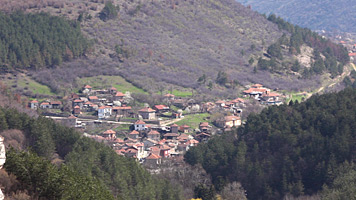
Reselets Village is situated in a sheltered valley
between the last hills of Veslets and the farthest west points of
Vratsa and Pleven districts, at 6 km to the west of Cherven Bryag,
touching the left bank of Iskar River at altitude of 101 m. It is
surrounded by Glesh hill to the north and Glamea hill to the south.
Squeezing through pinnacles and rocky peaks, coming from Veslets,
the small Rachene River, which never dries up, splits the village
in two halves.
In the past, Reselets Village was popular for its watermills – karadzheyki.
Since ancient times, when these areas were first inhabited, the waters
of Rachene River and Belilkata River served as main drivers of many
water utilities – watermills, fulling-mills, carders, etc. During
the years, they provided means of living and economic growth to the
habitation.
Village climate is extremely favorable for curing lung diseases. According
to experts, the air changes several times in 24 hours there.
Historical background
Reselets used to be a big medieval castle town, important administrative
center in medieval Bulgarian state, which was called Reselcha or Reselja
(Turkish). In 17 century it lost its town status and was listed as
village. Many ancient names are preserved on its territory: Bragles,
Vranitsa, Vagrenitsa, Golesh, Glamea, Juglata, Kreshta, Ostroga, Pukela,
Prokopanta, Propasishte, Raztoka, Rudinata, Stublata, Chutna, etc.
These names are evidence of the ancient origins of the village and
the fact that human activity here has not been interrupted for long
time periods.
Turkish conquerors inherited it as a town and large administrative
center. In the first centuries of the Turkish yoke it was known as
vilaet (district), Reselets being the center.
Reselets Ziamet (territorial unit) included the town of Reselets and
three villages – Lipnitsa (now Lepitsa), Chomakovtsi and Gabrvets
(now Gabare). Eleshten, Suhache and Cherven Brayg were listed in the
Timars (territorial units) after the Ziamet.
Reselets was the seat of the feudal lord, who reigned over the entire
Ziamet. Orehovo beys and agas called it Kucuk Stambul (Little Istanbul)
and used to come here in summer with their harems looking for coolness
and good hunting in the age-old forests.
In the centuries that followed, village existence was documented in
soldier registers of Hiybolu Kaaza (region).
During World War II, in Kaleto area treasure-hunters found golden
coins with inscriptions and the image of Byzantine Emperor Constantine
the Great. This leads to the assumption that Kaleto existed even during
the Byzantine rule.
Multiple excavation in Kaleto area revealed valuable artifacts suggesting
that the castle had a special place in the strategy of the tribes
which used to inhabit the area in various periods of the distant past.
Preserved are parts of thick surrounding walls, and in the west end
of the area traces were found of cylindrical outpost and watch tower
foundations built of baked bricks. In the flat part, remains were
found of walls and edifices, and in 1960, during the excavation works
for the construction of a tourist hut, the workers found the foundations
of large rooms. The excavations for the water supply conduit along
the route from Dobranin Dol uncovered well-shaped and robust clay
pipes.
In 1952 near Cherven Bryag railway station at 2 km from Reselets,
in Bivolski Kamak area, among the ruins of an old building, workers
of the State Construction Association – Cherven Bryag Group, stumbled
across three silver utensils Two of those had engraved on them the
image of the Roman Emperor Licinius I (308 – 324). The inscription
around the portrait reads that the utensils were manufactured in 318
AD on the occasion of his ascent to the throne.
Spear tips and arrows were found in the same area as well as a sickle
dated back in the Iron Age, a stone hammer, a chrommel (manual stone
grinder), a marble tombstone of the Roman warrior Lucius Plinus dated
79 AD, a rectangular sacrificial alter with carved bull’s heads, Roman
clay utensils and a coin of Gordian III (238 – 244), a tombstone with
burial feast (found in 1904)